Mapping Brisbane History
|
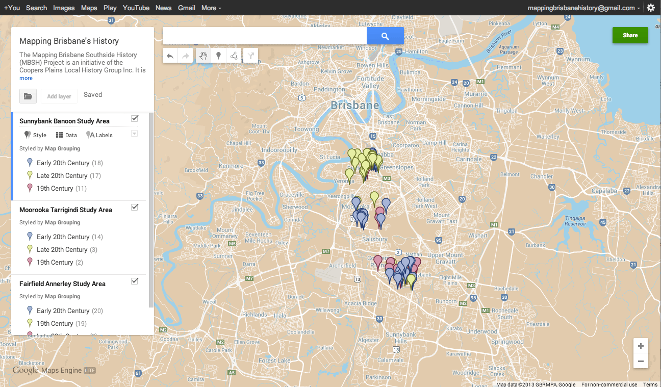
The Pilot Project The Mapping Brisbane Southside History Project was a project of the Coopers Plains Local History Group. It is now overseen by the Brisbane Southside History Network. The Brisbane City Council had supplied the Mapping Brisbane Southside History Project (MBSH) the amount of $6,800, from the 2012 Community History Grant provided to the Coopers Plains Local History Group Inc., for a pilot study of three local areas: Coopers Plains (Banoon)-Sunnybank, Moorooka-Tarragindi, and Fairfield-Annerley.
This project transformed at the end of 2013 as the Mapping Brisbane History Project, creating a website to service the Mapping Brisbane Southside History sub-Project, as well as future projects to map the history of other regions of Brisbane.
The MBSH Project Team consisted of three professional historians, Beryl Roberts, Janice Cooper, Neville Buch, as well as Chris Burns, a professional surveyor. Our first task was to gather all maps which gave us sufficient detail for the three local area pilot studies from five archives (SLQ, NAA, QSA, BCA). After mostly completing our collection of digital map images from various archives, the next stage of the project was to decide three to five comparative years for the study across the three local areas, based on common time-periods of the maps in the digital collection. Our choice of comparatives years also aimed at a spread across a century and half (e.g. 1860, 1885, 1935, 1961, 1975). In the following stages of the project, then investigated narrative and other documentary sources in relation to the local study areas in the common comparative years.
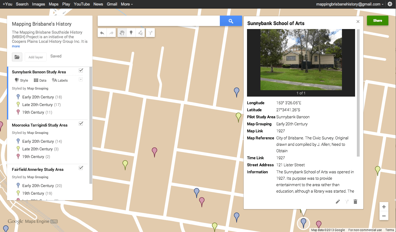
Once the specific data was collected, its cartographic details were combined and reproduced, using mapping software, into digital maps layered in different ways. The original vision was to start with the best information to display the basic topography as it was in the selected year, and then upon contour lines would be layered water-courses and vegetation, followed by transport routes and access passages (i.e. tracks, roads, streets). This could then be layered with the choice of boundary and property lines, such as Aboriginal tribal districts, parish and shire boundaries, electoral boundaries, real estate layouts, and land tenure. Further layers would be then be added. Houses, shops, and other commercial constructs are a few examples. However, technical difficulties arose in finding a mapping program which easily display these features with minimal work for the website user. This is where our Google Maps and Google Earth trials failed.
 The original aim for the project was that once all features that we have evidence for, from the historical data, have been illustrated, an imaginative layer could be added. This is detail where only partial evidence exists and some guess-work is used. For example, some guess-work could be used in completing the design of a building, the uncertain length of a street, the shape of a boundary, a previous contour level, and the direction of a water-course. Accuracy is the worthy aim in the project but historians clearly know the impossibility in recovering the exact experience of being in environments that are lost to time. The purpose of project is having the best symbolic recovery of local history environments possible and this would include an imaginative layer from the present vantage point.
 Stage Two of the Mapping Brisbane Southside History A project map could theoretically have any combination of layers. Each layer would cite all historical sources used in the map details. When an imaginative layer is added there would always be a statement of the exact extent of the guess-work. Any publication of map images will include citations and statements about the composition.
The pilot studies gave us the opportunity to assess the feasibility and requirements of a larger project beyond the trial mapping of the three local areas. It is hoped that mapping other local areas, using a different approach and set of technologies. In time, other teams in other projects could use the results of our project to employ the same methodologies in mapping other parts of Brisbane, and eventually the outcome would be a digitalised collection of historical maps for Brisbane city.
Currently the BSHN teams is adding nine more study areas to the existing three study areas, hence, we have connected the central Brisbane Southside between the Oxley Creek and the Norman Creek, from just below Highgate Hill and north Woolloongabba to the southern Brisbane City boundary. It leaves the West End-South Brisbane-north Woolloongabba, and the areas west of the Norman Creek, for stage three. In the near future there may be plans for another research team to look at the Bulimba area, and those plans can be accommodated.
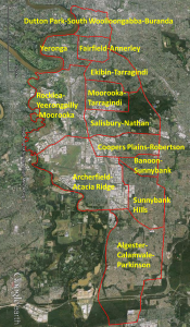 There are four rationales in forming this particular patchwork of study areas. First the original areas of Fairfield-Annerley, Moorooka-Tarragindi, and Banoon-Sunnybank will require refinement. Secondly, the best approach in expanding the Brisbane Southside mapping is to join together the pilot areas. Thirdly, we have particular interest in the most (currently) northern area for the sub-project (Dutton Park-South Woolloongabba-Buranda). Fourthly we have particular interest in the most southern area for the sub-project (Algester-Calamvale-Parkinson). |